

The first fall of snow is not only an event, it is a magical event. You go to bed in one kind of a world and wake up in another quite different and if this is not enchantment then where is it to be found?
J.B. Priestley
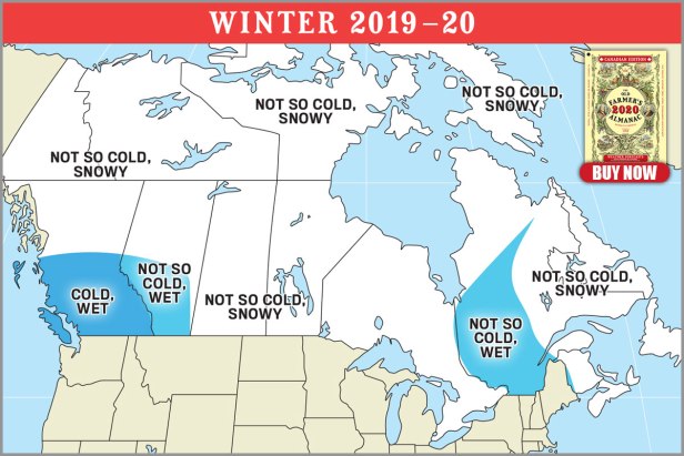
Another winter season is upon us and has started early for many across Canada. Can we expect more of the same; cold and snow, or a milder, easy winter. Let’s take a look!
The Long Range Models
Here is the latest from the long range models for December to February. Keep in mind, most of these models don’t have an overall great performance.
CFS – Temperatures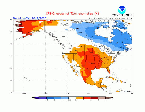
CFS – Precipitation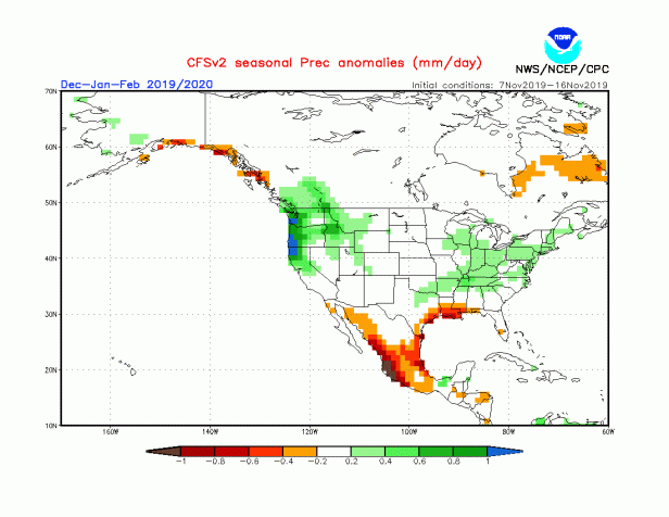
NMME Temperatures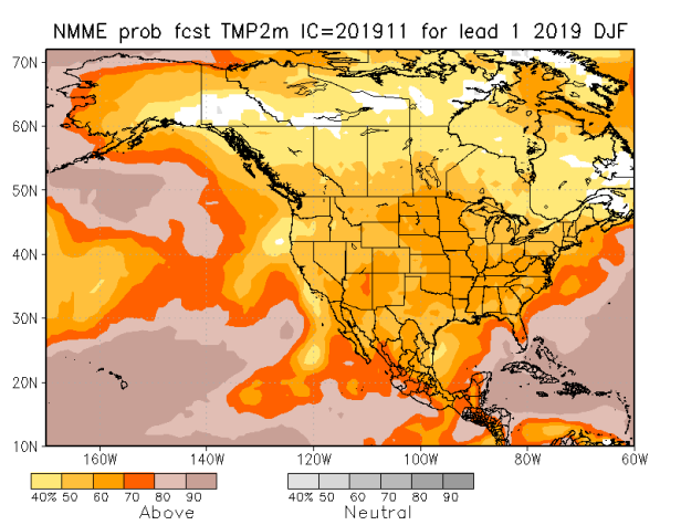
NMME Precipitation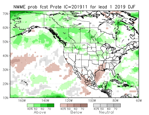
JAMSTEC Temperatures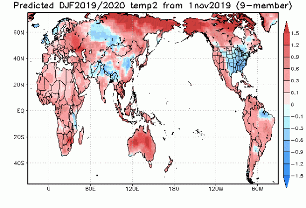
JAMSTEC Precipitation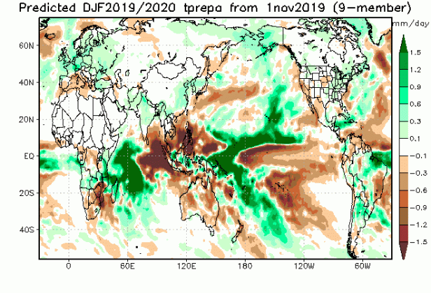
Euro Temperatures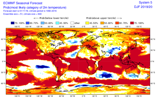
Euro Precipitation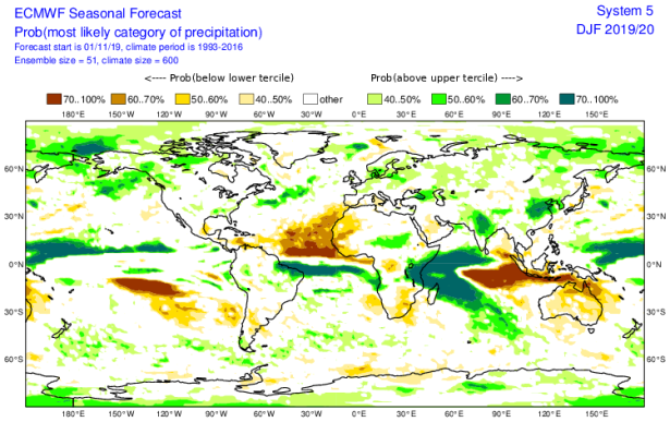
To summarize for Ontario and Quebec;
- The CFS is normal to slightly below normal temperatures and normal precipitation
- The NMMA is 40 to 50% chance above normal temperatures and normal to 40% chance above normal precipitation
- The JAMSTEC is mostly below normal for temperatures and above normal for precipitation
- The Euro is normal to slightly above normal temperatures and normal precipitation
Outlooks from other agencies
Now let’s take a look at the professional winter outlooks.
Environment Canada Temperatures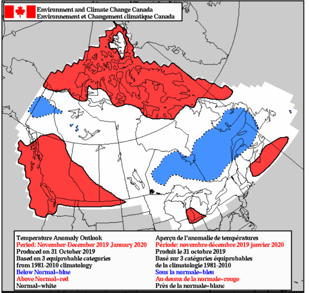
Environment Canada Precipitation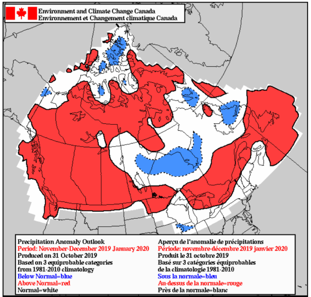
The Weather Network Temperatures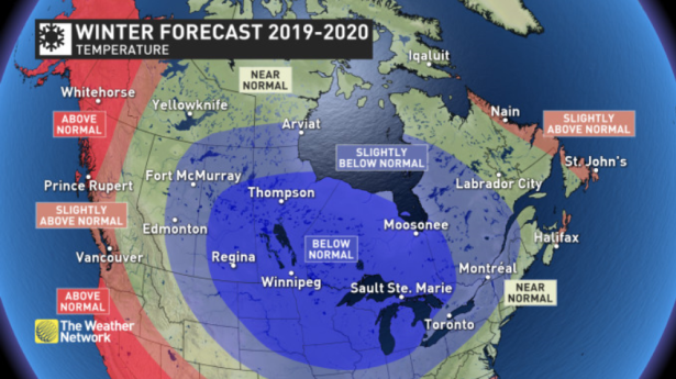
The Weather Network Precipitation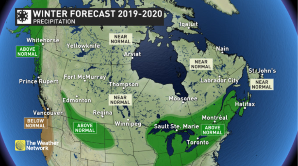
Accuweather (Brett Anderson) Temperatures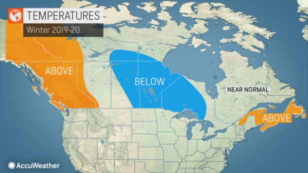
Accuweather (Brett Anderson) Precipitation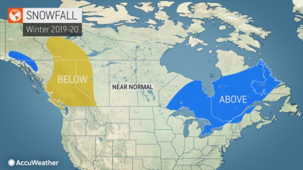
To summarize for Ontario and Quebec;
- EC is normal to slightly below normal temperatures and above normal precipitation
- TWN is below normal temperatures and above normal precipitation
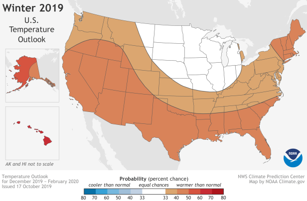
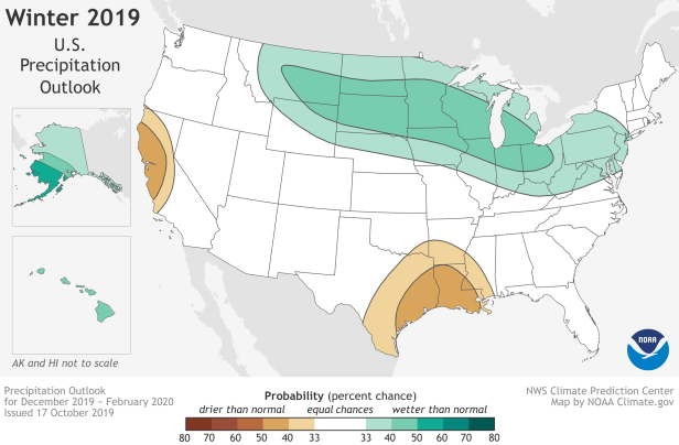
- The NOAA is 30 to 40% chance above normal temperatures and normal to 40% chance above normal precipitation
- Accuweather is normal to below normal temperatures and above normal precipitation
- The Farmers Almanac is normal to slightly above normal temperatures and above normal precipitation.
Analog Years
Analog years are past years with similar atmospheric conditions to this year. As I previously discussed, we look to be in a neutral ENSO pattern this year. Based on these conditions, below are analog years that I favour for this year, along with the temperature and precipitation historic data from December to March.
1959 – 1960 Temperatures: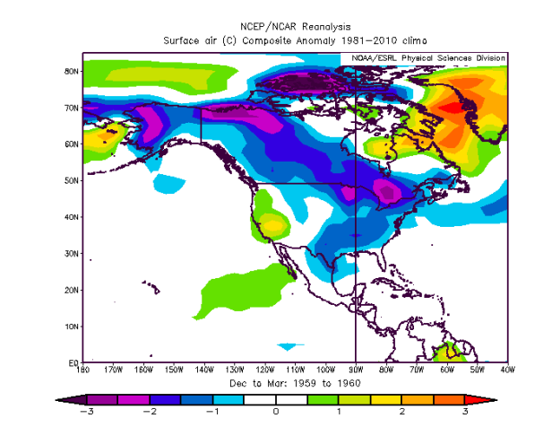
1959 – 1960 Precipitation: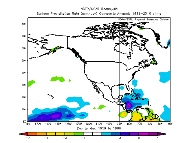
1967 – 1968 Temperatures: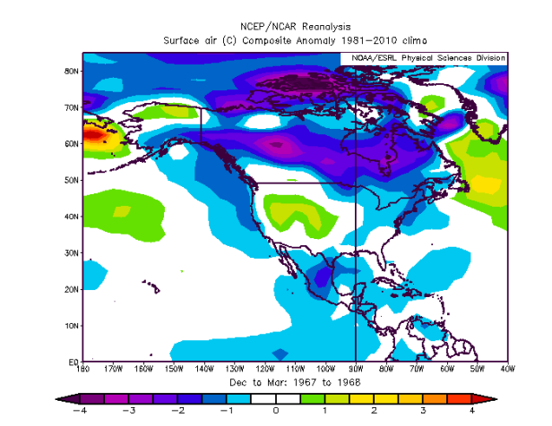
1967 – 1968 Precipitation: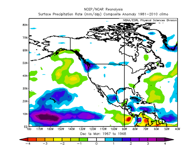
1993 – 1994 Temperatures: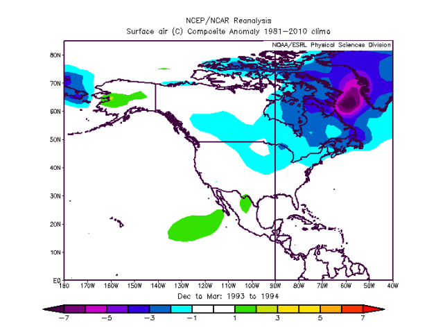
1993 – 1994 Precipitation: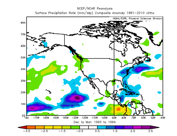
1996 – 1997 Temperatures: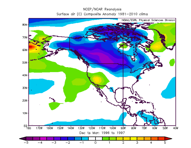
1996 – 1997 Precipitation: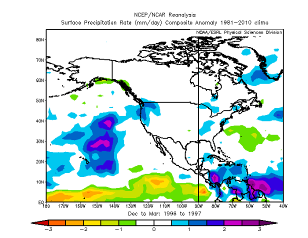
2013 – 2014 Temperatures: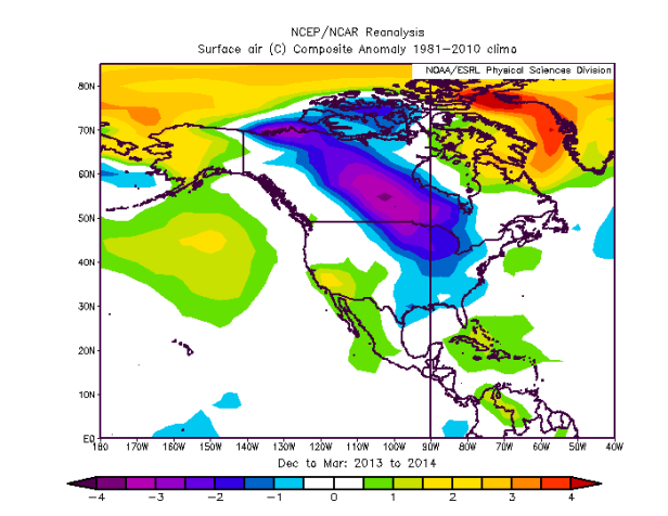
2013 – 2014 Precipitation: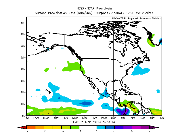
I chose these years based on neutral ENSO years with a colder start to November similar to this year. There were other neutral ENSO years without a cold November to consider as well;
1952/53, 1963/64, 1981/82. 1984/85, 1990/91, 2001/02, 2004/05.
Since no two winters are alike, these are just statistics to consider, but you can see that chances are this winter will be colder than normal, rather than above normal based on the analogs alone.
My forecast
My thought is that most of Canada will see a normal, average Canadian winter. The exception is the East and West coasts which should be above normal temperatures and slightly below normal in Manitoba and parts of Northwestern Ontario. While there will be periods of cold temperatures in January and February across the Prairies into Ontario and Quebec, there will also be periods of warmth, particularly in December.
Province Breakdown
BC
Expect a general normal winter in the mountains, however above normal temperatures may decrease some of the snow on the coastal mountains, while the Rockies may see above normal snow thanks to an early start to winter. I expect Vancouver will see a general warmer winter with slightly less rain.
Alberta/Saskatchewan/Manitoba
Most of the Prairie provinces will see a normal winter, with normal snowfall. Parts of Saskatchewan and Manitoba may see below normal temperatures, particularly in January and February. Although Alberta seen an early start to winter, I expect episodes of brief warmth and some dryness throughout the winter may even things out.
Northern/Central Ontario
After an early start to winter, expect good snow conditions across the region, despite a warm up in December. The Northwestern region of the Province over to Timmins stands a better chance of keeping snow on the ground right through the season, than areas of Central Ontario, from Sault Ste Marie to North Bay. It should be a decent snowmobile season, and extreme cold could take hold in January to push the northern regions to slightly below seasonal.
Southern/Eastern Ontario
After our false early start to winter in November, conditions will warm into December, with actual winter conditions taking hold again by mid to late December. The overall storm track is expected to be over the Great Lakes, so many systems should impact this region to push it slightly above normal, but not all will be snow. Expect some rain/mixing and ice storms across the region that may make it difficult to keep consistent snow cover in the southern portions of the province, especially early on. However, the right ingredients might be present to make some decent, strong snowstorms throughout the season, especially end of December into early March.
The snowiest weather will likely be the end of December to the middle of January and again in early February.
There should be decent outbreaks of Lake Effect snow, mid to late December, into the middle of January, before we see the Lakes start to freeze up.
I do expect that most of Southern and Eastern Ontario will have a White Christmas, but more on that later.
Quebec
Southern Quebec will be similar to Southern Ontario in terms of temperatures and a chances for above normal snow. I do expect coastal storms may increase snowfall from Montreal, particularly up to Quebec City and the Gaspe region.
The Maritimes
Similar to the west coast, I do expect New Brunswick, PEI, Nova Scotia and parts of Newfoundland will see slightly above normal temperatures. However, increased strong coastal lows, particularly in December to February may push precipitation above normal. While there will be rain associated with these lows, I also think increased snowfall will be seen in the region.
Where my forecast can go wrong?
This forecast was extremely tough to predict. With the ENSO conditions at neutral, we wont get much help from El Nino or La Nina typical patterns to prepare the forecast. That means we have to look at the other teleconnections for guidance. Conditions like the NAO, AO, PNA and EPO can only be predicted within a couple weeks of the event and not long term ahead of the winter. They are also very hard for the medium and long range models to pick up on these conditions.
In a positive NAO scenarios, expect the below: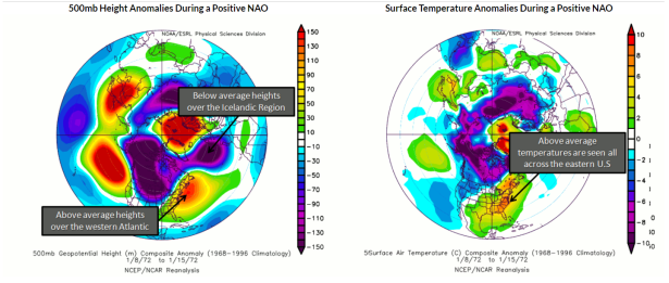
While in a negative NAO scenarios, means: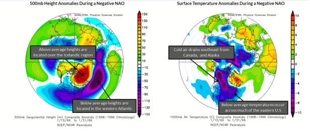
Similarly, a positive AO scenarios means: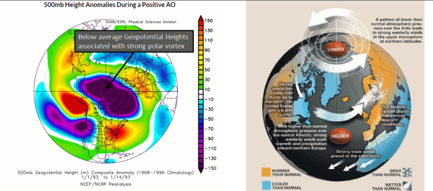
While a negative AO scenarios means: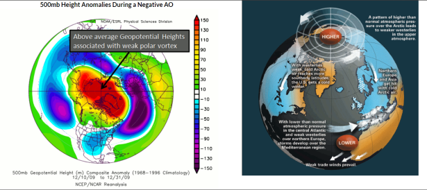
The above images are from this great site.
With either, or both of these forces in control at once, the temperatures can swing wildly and you can go from a very cold pattern, to a warm pattern rather quickly. I talked about this “roller-coaster” of temperatures back in October in this blog post.
Therefore, I could be misinterpreting any of the above model signals and these shorter range phenomenons end up taking control and changing the outlook. However, if anything, I would say my forecast is too warm, rather than too cold. Most of my forecast is based on the long range models, like the Euro and JAMSTEC, rather than the analogs. It is possible that we see long periods of Polar Vortex or cold outbreaks that end up pushing the average normal temperatures profiles below seasonal for an extended period of time. You can see in the analog years I choose, that very cold conditions were present for most of the winter.
In addition, too much cold can be a bad thing for a snowlover, as a polar vortex usually sets up in a strong areas of Arctic high pressure over a southern region. This could push storms away from the Ontario region, over to the East coast. This would drop the predicted above normal snows for Ontario and Quebec.
Based on the above, my confidence level for this forecast is rather low at about 60 to 70%. I expect at times this winter, I will get this wrong.
Summary
Overall, most of Canada will see a normal, proper winter. Outbreaks of cold temperatures will be possible, but we could also see moderating periods, especially in December, February and March. It will also likely be wetter and snowier across portions of Ontario, Quebec and the East Coast at times.
Happy Winter to all!
Cover image from wallpaperbro.com

Nice forecast jj. Always difficult to make a winter forecast when there is not one significant driving force like El Niño or La Niña. I think you’re forecast is quite good given the information we have currently.
I think it should be a fun season for tracking storms when true winter takes hold into December.
Thanks for putting in the time to do such a detailed forecast.
LikeLiked by 1 person
Thanks Snowbob 🙂
LikeLike
Thank you for your winter forecast! Where did Big MT go? He disappeared! thanks JJ. 5166@yrp.ca
LikeLiked by 1 person
Thanks Cathy. He decided to leave the blog page, not sure where he landed.
Happy winter season 🙂
LikeLike