
Temperatures will warm into the upper 20s tomorrow, combined with dewpoints in the low 20s, resulting in a great deal of CAPE, likely over 2000 j/kg (with some models featuring over 3000 j/kg).
However, shear will likely be on the marginal side, but as CAPE increases, the balance needed to achieve severe weather begins to tip in favour of CAPE, especially with values over 2500 j/kg. 500 mb winds to 30 kt should be sufficient to promote some storm organization and damaging wind gusts, when combined with mid-level dryness as shown here 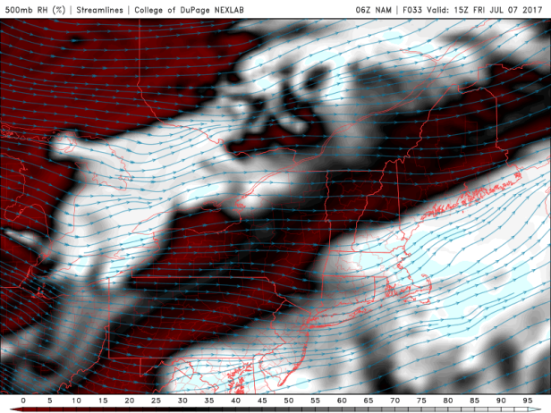
Another major concern is storm motion. The following 06Z NAM sounding from the Montreal area depicts an estimated storm motion (mean 0-3 km wind) of only 13 kt, which is only about 23 km/h, which may result in very heavy rainfall amounts in some areas due to the storms.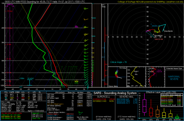
The potential for large hail also accompanies some of the stronger cores, especially with relatively low WBZ levels. As late week demonstrated, modest CAPE (considerably less than here) and weak bulk shear yielded large hail in various locations.
Severe thunderstorms may also occur in the Montreal area and points east on Saturday, but timing and parameters are still highly debatable.

The 12Z NAM develops a 1000 mb mesolow near Montreal in the afternoon hours, as well as local rainfall totals to 55 mm.
Most models have morning storms to the north of Montreal that could potentially extend into the Ottawa Valley, but areas to the south should warm up nicely in the morning and be hit quite hard once the convection drops into those areas.
LikeLike
Severe thunderstorm warning in SW ON this morning, upgraded from an earlier SWS.
LikeLike
That warning is over but watches remain in place for parts of QC regarding afternoon storms.
LikeLike
They should be expanded to the west because most models have the strongest updrafts occurring in the St. Lawrence Valley near Montreal this afternoon.
LikeLike
Despite early morning convection and cloud cover, trends are good and there are no changes to the convective threat.
Despite intermittent sunshine, my temp increased by 1.9 C in 43 minutes to 22.7 with a dewpoint of 20.2, resulting in 1250 j/kg of SBCAPE. However, H85 dryness may cause the BL to mix out though.
LikeLike
Severe thunderstorm watches are in place for SW ON once again.
LikeLike
We’ve broken the 2000 j/kg SBCAPE barrier. I’m watching the field of clouds and showers in eastern Ontario.
LikeLike
I’ve had some sporadic showers this morning but breaks of sun are coming through now. It’s certainly muggy out.
LikeLike
We finally have some convective initiation near Casselman.
LikeLike
Cloud cover is declining in the Seaway, which should give that line of showers approaching Montreal a chance of being something substantial. Otherwise, it will be placed in the “waste of 2100 j/kg” folder.
LikeLike
We’re under a watch here now as a line of storms moves in from the west with some scattered cells developing ahead of it.
LikeLike
That cluster could make it here early this evening.
In fact, CAPE values are expected to be over 1000 j/kg into the overnight hours combined with increasing bulk shear.
LikeLike
Something strong finally developed around here but it missed me by 15 km. 😦
LikeLike
Many storms are popping up in E ON, including a large squall line near Ottawa.
Some of them are severe pulse storms that strengthen to 60 dbz before producing microbursts and potentially hail. Not to mention the rainfall potential from the training squall line (over 25 mm in some spots already)! Warnings need to be issued.
LikeLike
Storms rolled through here with a quick-hitting 15mm along with some lightning. Tapered to light showers now.
At least we were able to dry out these last few days so the ground could actually absorb the moisture this time around. We were completely saturated before that quieter spell.
LikeLike
Radar estimated rainfall totals in the Richelieu Valley were topping 60 mm as of recent.
Looks like we’ve reached convective saturation and everything’s starting to die off as a result.
There will be more strong to severe storms in southeastern Quebec and the Montreal area tomorrow morning and afternoon.
LikeLike
Surprisingly, a severe thunderstorm is affecting the Toronto area right now, with reports of hail up to 4 cm.
And here, we’re about to get some convective activity, although it is not very strong.
LikeLike
Hail-producing severe thunderstorms are now affecting Ontario’s cottage country. They must be producing lots of wind as 30 000+ are without power.
LikeLike