
It appears that the greatest severe weather potential today will be in southern Ontario and southwestern Quebec where a squall line may produce damaging winds and isolated large hail late this afternoon and this evening. Scattered thunderstorms may also form between Cornwall and Montreal early this afternoon, which may produce over 25 mm of rain due to slow storm motion.
The likelihood of a major severe thunderstorm event on Sunday is increasing in eastern Ontario and southern Quebec. Surface winds are still expected to back to the south and southeast in southern Quebec, resulting in sufficient helicity for supercell development in addition to over 35 kt of effective bulk shear. CAPE over 3500 j/kg combined with DCAPE over 1000 j/kg, 45 kt low-level winds, and good low-level lapse rates will result in conditions conducive to downbursts. Low LCL heights and STP values over 2 locally may result in isolated tornadic development. Stronger cores could also produce large hail.
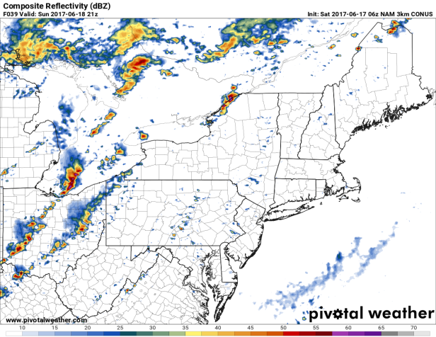
06Z NAM 3K simulated radar for 5 pm Sunday.
After sunset, CAPE will inevitably decrease but PWATs will increase to over 2″ in a saturated sub-freezing layer. Low-level winds will weaken resulting in slow storm motion and the potential for storms with very frequent lightning to produce torrential downpours with over 50 mm possible.
Linear convection moving from the Eastern Townships of Quebec to western New Brunswick will occur on Monday. Faster, unidirectional low-level winds will prevent training and flooding from occurring in those regions. Damaging winds and large hail is possible.

Tornado warning for London right now!
However, the rotation in the supercell affecting the city right now does not appear to be very intense.
LikeLike
Some potent storms have rolled through with multiple previous warnings across S ON. Watches currently remain in place over a large portion of the region.
Montreal is under a heat warning for tomorrow now as well.
LikeLike
Barrie now has a tornado warning, due to at least 3 or 4 bookend vortices closing in on the area. Ottawa has good tornado/supercell parameters right now, but almost no low-level forcing.
It’s crazy, considering that this is basically a preview of tomorrow’s weather in Montreal except with potentially twice the CAPE (they have up to 2000 j/kg right now).
LikeLike
I just noticed that Toronto had a tornado warning as well this afternoon.
The models have sped up the timing of tomorrow’s storms as of their 00Z runs. Thus, they now show some weak thunderstorm cells move through Montreal early in the afternoon, moistening the atmosphere and creating an “extreme parameter vacuum” for the early evening convection. Very dangerous considering that everything will be HP and in urban areas.
LikeLike
Warm and muggy out here this morning, already 20c at 7 AM. See what fires up today in this airmass.
LikeLike
Now 25/20 in Possum Lake with 1000 j/kg of SBCAPE already. A squall line has already developed from Toronto to just east of North Bay.
LikeLike
That initial line is headed this way but it seems as if the subsequent one expected later in the day could be more intense when it develops.
LikeLike
Severe thunderstorm watches are now up for S QC.
LikeLike
Severe thunderstorm and tornado watches are also in place for much of S ON now.
LikeLike
It appears that the first squall line isn’t producing much in terms of wind as virtually no power outages have been recorded with it (except for one involving 300 customers in Aylmer).’Now it has transformed into supercells with hooks (but no outflow thus no rotation yet).
CAPE is up to 2700 j/kg and we’re just waiting for the LLJ to move in to increase moisture and the supercell potential here.
LikeLike
A funnel cloud has been spotted near Joliette. Prepare to see a lot in the next 6 hours. At 2:28, a tornado warning was issued for the Joliette area. The rotation is marginal but tight.
LikeLike
Severe thunderstorm warnings with the activity in SW ON as well.
We’re still under a tornado watch here. The first line of earlier storms was mainly rain and wind at my place; back into warm and humid conditions at the moment.
LikeLike
Looks like a good call seaway. Warnings are expanding rapidly across both Provinces as things escalate this afternoon.
Multiple tornado warnings currently up, both to the west of here and across the border.
LikeLike
The second line of storms is approaching now. The tornado watch has ended but a severe thunderstorm watch remains in place.
Some of the cells in QC may have produced tornadic activity based on radar.
LikeLike
The town of Hebertville near Saguenay was presumably hit by a tornado yesterday. Videos of a condensation funnel located near the ground aired on French news networks. They also showed a home missing its roof and several exterior walls in the vicinity.
LikeLike
Yesterday’s storms made quite an effort to avoid the St. Lawrence Valley. We haven’t received a decent surface-based storm so far this year, which is almost unprecedented. July/August should be better with evapotranspiration from crops and the warming of bodies of water.
LikeLike
Bit of disappointing 2 days for storms in the Ottawa area. Conditions were there, just didnt come together in time. Looks like Quebec and SW ON got the most activity. We had a small thunderstorm role through very early this morning, which was only about our 3rd storm for the year so far….
LikeLike
I also got a couple thunderstorms this morning with torrential rain and gusty winds. We’re at 13 for the year, but it’s been about quantity more than quality.
It annoys me looking at lightning maps and seeing storms in the high Arctic whilst the St. Lawrence Valley gets nothing.
The GFS has lots of highs in the low 20s and even upper teens for the next 10 days. It will be quite humid, so some cold-core hail-producing storms may occur.
LikeLike