
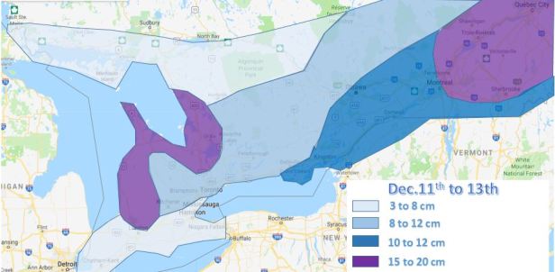
EDIT: Map has been issued below.
The first widespread, more significant snow storm of the season looks to impact Southern Ontario on Tuesday December 12th.
I have discussed in the White Christmas blogs that the amplified pattern would bring cold and some Alberta clipper storms that can sometimes develop into more than a 2 to 5 cm storm.
Most models have a clipper coming in Monday night into Tuesday that rather than speeding through Ontario, it slows down as the storm strengthens and transfers to a stronger coastal storm.
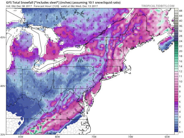
Here is the latest from the GFS – with snow totals (direct hit for S.Ontario, all snow):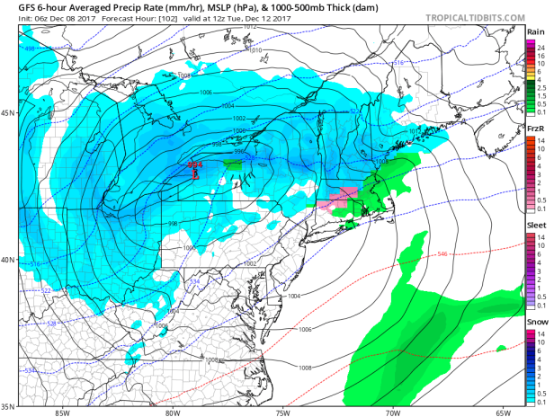
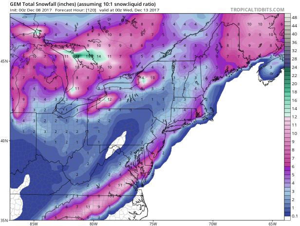
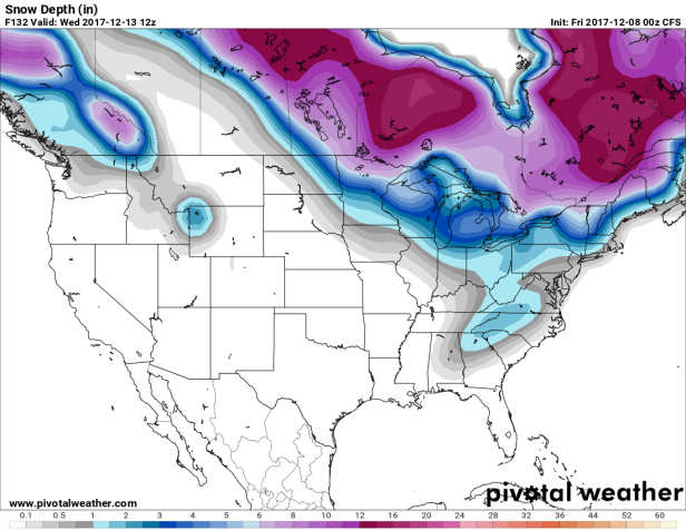
From the GEM (CMC) with snow totals (earlier and further north with some rain around Lake Ontario):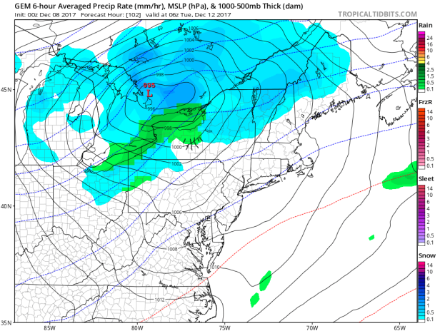
And the CFS with snow totals (similar to the GFS):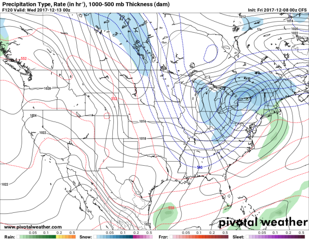
The thing to keep in mind with the coastal transfer systems:
- Sometimes the strengthening does not occur over our region and the storm continues on its quick path to the coast,
- the energy transfer to the coast can happen very quickly and the storm essentially dies out over Ontario (this commonly happens over E.Ontario and SW. Quebec and we loose a great deal of moisture)
Also the system could slip south of Ontario, as the Euro model suggests, which would also limit totals.
Here is the Euro’s latest placement of the low further south of Ontario: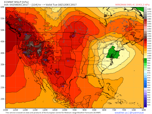
and the snow totals: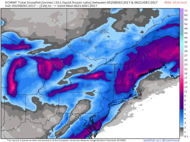
For now here is my thoughts for snow totals: (the timing is late Monday, overnight into Tuesday evening):
Ottawa – 5 to 10 cm
Belleville and area – 5 to 10+ cm
Toronto and the GTA – 5 to 10 cm
Hamilton down to Niagara SW Ontario – near 5 cm, possibly more near Lake Erie
Windsor to London – 5 to 10 cm, (possibly 15+cm up towards Lake Huron and snowbelt regions)
Wasga Beach over to the Muskoka’s, Barrie and Central Ontario – 10 to 15+ cm
Sault Ste Marie over to Sudbury & North Bay – 5 to 15 cm (depends on whether the lows stays south or goes further north)
I will add a map to this post and update totals this weekend once we have some more model run consistency.
Map issued Dec.10th:

Thanks JJ… no mention of it yet on Accuweather for snow totals… Would you lump Newmarket in with the GTA, we are north of Highway 7 which is usually the cut off line for heavier amounts of snow… thanks! I am excited!
LikeLiked by 2 people
Hi Cathy,
I would say you are closer to the higher amounts of the 10 cm estimate based on your northern location.
Hoping this plays out nicely so we all get some snow 🙂
LikeLike
12z runs of the GFS & CMC didn’t deviate much from their respective camps as you outlined. GFS tracking south and CMC to the north. 12z Euro yet to weigh in until the afternoon.
Still could be another similar scenario around a week from now perhaps.
LikeLiked by 1 person
12z ECMWF is closer to the GFS idea, bringing the clipper system along the lower lakes before heading NE towards QC/NB. Limited strengthening as it does so in this interpretation, especially compared to earlier mid-range solutions which were pretty intense.
LikeLiked by 1 person
Snow totals for Province of Quebec ?
LikeLiked by 1 person
Good point Seb, since this is the Ontario/Quebec section I’ll make sure to include you.
Right now I would say most of S.Quebec, including Montreal, is in the 5 to 10 cm zone similar to Ottawa. Possibly more towards Quebec City and the Gaspé.
LikeLike
If things play out as they look like they might atm, then good job to the GFS for being the first model to really show this potential. It has basically stuck to its guns for the last few days while the other models weren’t showing much for ON/QC.
LikeLiked by 2 people
Some 18Z GEFS members have a very early phase where there is next to nothing for most of S/ E ON but a lot (15-30+ cm) for Montreal and east.
LikeLike
The 12Z EPS’ probability of 15+ cm (at 10:1 ratios I think) in Ottawa is about 20% and in the Montreal area it ranges from 20-40%.
All the snowstorms last winter only appeared on the models around 4-5 days out over here. Farther out, they were usually depicted as more hostile situations.
LikeLiked by 1 person
The 00/06Z global models and the NAM have put Montreal in a favourable situation, all featuring over 15 cm as the low strengthens and WAA strengthens over S QC. I could see 30 cm in some locations in S QC.
LikeLiked by 1 person
E ON is also in a good position but GGEM/NAM-like solutions almost completely shut out the GTA (5 cm or less).
LikeLiked by 1 person
Map has been updated for the storm.
LikeLike
5 cm down at 6 am this morning IMBY. Looks like another 10 cm or so today, more probably east end of Ottawa towards Quebec. Montreal and Southern Quebec should be in for at least 20 cm, possibly more.
LikeLike