
A strong low-level jet will be present over S/E ON and S QC throughout the day tomorrow as temperatures warm into the lower 20s. However, CAPE should only be in the 250-500 j/kg range in most areas. Nonetheless, the combination of extreme shear (65-75 kt at H85; 90 kt at H5) and strong frontogenial forcing along a cold front will allow of the development of a powerful squall line with widespread wind gusts in excess of 90 km/h as shown here: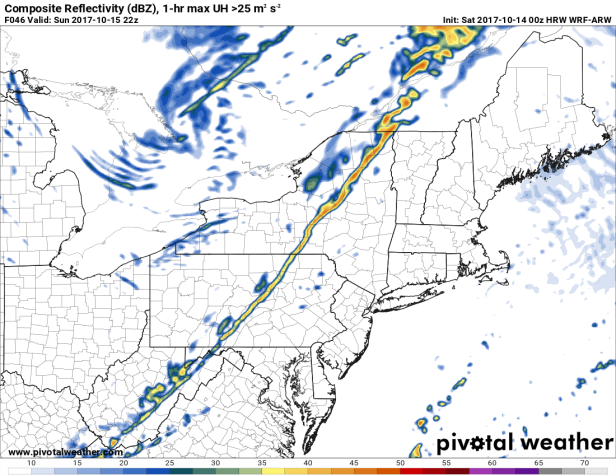
The line is expected to develop in SE MI or SW ON late tomorrow morning then move into SE QC early in the evening.
Little in the way of lightning is expected due to the marginal instability but the intense rainfall in low-topped squall lines will easily bring down the low-level jet to the surface as is typical of most cool-season squall lines.
Wind gusts on Lakes Erie, Huron and Ontario could exceed 120 km/h with the passage of the line.

SPC upgraded to slight risk for E ON and the Montreal area.
Currently 15 with light rain; looks like some surface warming should take place as we enter a dry slot.
Some models have cells developing ahead of the frontal line that basically pre-empt the latter near Montreal. Damaging winds are still very possible if they develop into a line.
LikeLike
The squall line has developed just NW of Windsor and Sarnia. An SWS for that line indicates the potential for 70-90 km/h wind gusts. More cells are popping up north of Toronto and north of here as well.
Dewpoints will be pushing 20 C in some locations in E ON and S QC late this afternoon.
The HRRR has STP values in the 1-2 range in those areas as well. We’ll have to see how this transpires…
LikeLike
That SWS is now a severe thunderstorm warning. I hope that EC is wide awake today…
LikeLike
104 km/h wind gust in London and over 5000 customers without power.
LikeLike
This could very well end up being a derecho. There are reports of significant damage on the Instant Weather Ontario FB page, including flying sheds and the 850 mb winds are continuing to strengthen (currently at 60 kt; they could reach 80 kt by the time the line hits Montreal).
There is some mid-level dryness around here, which could make the situation even worse.
LikeLike
The outage number is now up to over 10 000, just before the line slams into Toronto.
LikeLike
Despite a large number of shifting weather statements and warnings across the region we’ve yet to have either in place here so far. We’ll see what happens with the activity approaching from the west.
Looks like a brief but forecful cold shot in the near-term before we head back above-seasonal this week. A drier spell seems in the cards as well.
LikeLike
We have a frost advisory now. I’d issue something else, one that is relevant to the scope of this post, but it’s too logical for EC to consider.
LikeLike
The old line is starting to weaken and a new one is taking its place on the eastern shores of Lake Ontario. Still severe, though.
LikeLike
They’ve issued a SWS here – http://weather.gc.ca/warnings/index_e.html
“Strong southwest winds with gusts to 70 or 80 km/h are expected to develop late this afternoon ahead of a cold front. A line of heavy showers and possible thunderstorms will accompany the gusty winds.
The winds are expected to slowly diminish this evening after the frontal passage.
At this point, wind warnings are not anticipated. However, the situation will be monitored closely.”
The winds warnings have decreased in coverage but some remain in place.
LikeLike
Storms moving over my place now with windswept heavy rain.
LikeLike
Wind warning now in effect here.
LikeLike
That storm did a number on Ottawa with numerous power outages and a recorded 97 km/h gust. I had some heavy rain ahead of the main line which is coming in soon.
LikeLike
There are now unconfirmed reports of a tornado in Mont-Laurier, which would be the second October tornado in Quebec’s history, and the third in that town since 2009. The only confirmed October tornado in provincial history was the one of them.
LikeLiked by 1 person
The squall line moved just to my north, producing light rain and moderate gusts here.
LikeLike
EC’s has a summary of the winds for ON – http://weather.gc.ca/warnings/weathersummaries_e.html
“ONTARIO
AWCN10 CWTO
Weather summary
for Ontario and the National Capital Region
issued by Environment Canada
at 9:34 p.m. EDT Sunday 15 October 2017.
Discussion.
A cold front swept across Southern Ontario on the afternoon of
October 15th. Along this cold front a narrow band of heavy showers
developed along with strong gusty winds. Throughout Southern Ontario
these strong winds resulted in numerous downed trees and power
outages.
The following is a summary of peak wind gusts recorded by
Environment and Climate Change Canada in kilometres per hour:
London Airport: 104
Toronto International Airport: 102
Ottawa Airport: 96
Long Point: 95
Point Petre: 95
Toronto City Airport: 91
St. Catharines Airport: 89
Port Colborne: 85
Hamilton Airport: 82
Please note that this summary may contain preliminary or unofficial
information and does not constitute a complete or final report.
End/OSPC”
LikeLiked by 1 person
QC’s summary is available now too, confirming an EF0 tornado.
CBC has some pictures of the damage here – http://www.cbc.ca/news/canada/ottawa/weather-tornado-windstorm-mont-laurier-quebec-laurentians-1.4356332
“QUEBEC
AWCN10 CWUL
Weather summary
for Quebec
issued by Environment Canada
at 10:40 a.m. EDT Monday 16 October 2017.
Discussion.
A low pressure system from the Great Lakes tracked from west to east
across Quebec on Sunday. Near the low and its associated cold front,
an EF-0 tornado struck Mont-Laurier, specifically in the chemin du
Lac Nadeau area. Several buildings were damaged.
Additionally, several regions near the track of the low received
significant rainfall amounts. Below is a summary of rainfall amounts
reported (in millimetres).
Upper Gatineau
Wakefield 86
Bristol 48
Val-des-Monts 41
Lower Laurentians
Saint-Jovite 47
Mauricie
Maskinongé 51
Shawinigan 46
Trois-Rivières 43
Lanaudière
Saint-Cléophas-de-Brandon 61
Saint-Barnabé 52
Greater Quebec
Deschambault 45
Saint-Édouard de Lotbinière 48
Saint-Antoine-de-Tilly 68
Beauport 46
Sainte-Foy 57
Cap-Tourmente 55
Charlevoix
Le Massif 61
Laurentians Wildlife Reserve
Montmorency forest 48
Saguenay
Onatchiway 50
Hébertville 45
South Coast
La Pocatière 44
Saint-Pierre-de-la-Rivière-du-Sud 52
Saint-Aubert 42
Lower St Lawrence
Pointe-au-Père 44
Gaspé Peninsula
Cap-Chat 43
Matane 46
Dunière 61
Please note that this summary may contain preliminary or unofficial
information and does not constitute a complete or final report.
End/QSPC”
LikeLike