
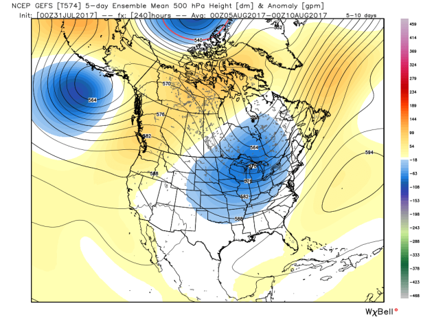
Noteworthy pattern re-amplification featuring a swelling western ridge and a resultant downstream trough will drive another spell of major heat for BC and the Pacific NW while unsettled weather returns to the GL.
This will put daily record highs in jeopardy for numerous west coast locations over the course of this week and prolong the tenuous wildfire situation as moisture deficits continue.
00z GEFS 500mb height anomalies, days 1-5:

Days 6-10:
WPC total QPF for days 1-7:

Current fire danger forecast with active fires overlay via the CWFIS:

Also meteograms for a few locales in BC from the latest 00z NAEFS.
Victoria:

Vancouver:

Kelowna:

Tropical Depression 6 has just recently formed off the western coast of Florida and is set to track E/NE across the state, then out into the Atlantic due to the steering influence of the eastern trough
It’s intensity forecast is rather subdued and the NHC predicts it will remain at depression status before dissipating. If named it would become Emily.
5-day forecast track:

A separate tropical wave in the MDR is being monitored but has a minimal 10% chance of developing over the next 5 days as it gradually heads toward the Lesser Antilles.

TD 6 has been upgraded to TS Emily by the NHC in short order, although intensity forecasts continue to be lackluster as land interaction and shear will likely restrain her moving forward – http://www.nhc.noaa.gov/
“At 800 AM EDT (1200 UTC), the center of Tropical Storm Emily was
located near latitude 27.7 North, longitude 83.2 West. Emily is
moving toward the east near 8 mph (13 km/h), and this general motion
is expected to continue today. A turn toward the northeast and an
increase in forward speed are expected tonight or Tuesday. On the
forecast track, the center of Emily is expected to move inland over
the the west-central Florida peninsula later today and move across
central Florida through tonight. Emily is expected to move offshore
of the east-central Florida coast early Tuesday.
NOAA Doppler radar data from Tampa, Florida, indicate that maximum
sustained winds have increased to near 45 mph (75 km/h) with higher
gusts. Little change in strength is forecast until landfall occurs
this afternoon. Emily is expected to weaken to a tropical
depression while it moves across the Florida peninsula tonight.”
LikeLike
The scorcher is dialing up for BC with SWS in place from EC – http://weather.gc.ca/warnings/index_e.html?prov=bc
“A heat wave is expected for the south coast of British Columbia…
A massive ridge of high pressure will build over southern BC through Thursday, leading to several days of hot weather. Daytime maximum temperatures will soar into the mid to upper 30’s by Wednesday over communities in the Fraser Valley, Howe Sound – Whistler and inland Vancouver Island. Temperatures will be several degrees cooler near the Straits of Georgia and Juan de Fuca.
Daily temperatures records from Wednesday to Friday will probably be broken in a few communities. And the all time records for the month of August might be threatened, too. For example, the highest August temperature ever recorded at Abbotsford is 36.3 degrees and the forecast for Thursday is 36.
Complicating the temperature forecasts is the presence of wildfire smoke. Smoke inhibits the transmission of sunlight and can lower daytime temperatures. The extent and concentration of wildfire smoke this week will be difficult to predict and will be the wildcard factor in determining whether record temperatures are achieved.
The heat combined with the lack of rainfall so far this summer will maintain high to extreme fire danger ratings across much of southern BC.”
LikeLike