
Yet another series of new daily high temp records were set again yesterday in the west.
BRITISH COLUMBIA
AWCN11 CWVR
Weather summary
for British Columbia
issued by Environment Canada
at 11:29 p.m. PDT Saturday 8 July 2017.

Discussion.

A strong upper ridge of high pressure over southern British Columbia
is giving high temperatures. Several daily records were broken on
Saturday, July 8.

Summary of daily temperature records in degrees Celsius.

Cranbrook area 35.5 (Previous record 35.2 in 1985)
Creston area 35.8 (Previous record 35.0 in 1985)
Nelson area 35.7 (Previous record 35.0 in 1970)
Sparwood area 33.1 (Previous record 32.7 in 1985)
Trail area 36.3 (Previous record 36.1 in 2015)

Please note that this summary may contain preliminary or unofficial
information and does not constitute a complete or final report.

End/PSPC
SASKATCHEWAN
AWCN13 CWWG
Weather summary
for Saskatchewan
issued by Environment Canada
at 8:41 p.m. CST Saturday 8 July 2017.

Discussion.

Southwestern Saskatchewan is on the periphery of a large mass of hot
air which has set up over western North America. A heat warning
remains in effect for southwestern Saskatchewan. In the old
Fahrenheit scale, some of these temperatures are triple digits.

The following locations set new record high temperatures today
(values given in degrees Celsius):

ASSINIBOIA
New record of 36.6
Old record of 36.0 set in 1983
Records started in 1915

CORONACH
New record of 38.2 or 101 Fahrenheit
Old record of 37.0 in 1989
Records started in 1971

ROCKGLEN
New record of 37.3
Old record of 32.3 set in 2001
Records started in 1971

VAL MARIE
New record of 38.5 or 101 Fahrenheit
Old record of 37.5 set in 1983
Records started in 1937

Another noteworthy temperature was the high of 37.8 in Mankota
today. This was just shy of their old record of 38.0 set in 1983.
37.8 is exactly 100 degrees Fahrenheit.

Please note that this summary may contain preliminary or unofficial
information and does not constitute a complete or final report.

End/PASPC
The number of fires burning through BC has jumped to 180+, with nearly 2000 firefighters combating them and many thousands displaced. The Red Cross has initiated an appeal for assistance.
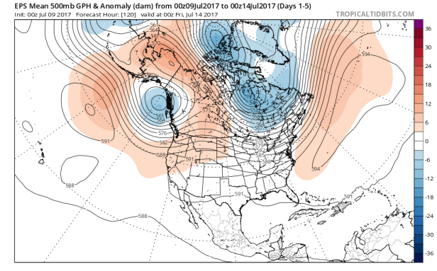
Ridging looks to stand mostly firm over the region through the next mid-term, bookended by an upper low in the NE Pacific and a downstream trough through the east.
00z EPS 500mb height anomalies, days 1-5:
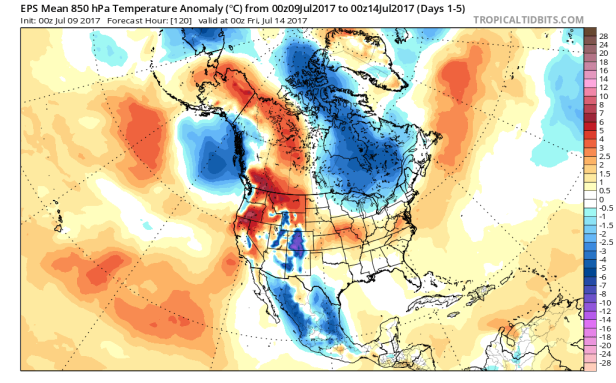
850mb temp anomalies, same timeframe:
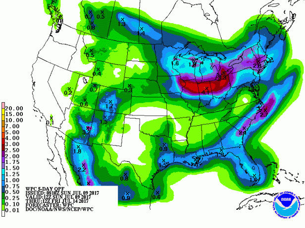
5-day total precip from the WPC:
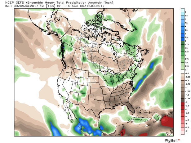
Precip anomalies for days 1-7 from the 00z GFS ensembles:

On the other hand, the GFS is forecasting highs around 13-16 C in S QC at the end of the week, when I’m going camping. 😦
LikeLike
*12Z run. The law of averages should save your bacon and give us some 36-39 C days in return!
LikeLike
*our bacon, oops.
LikeLike
I’m still savouring the fact we salvaged 3 dry days in a row here last week. We’re just shy of our July precip average now and it’s only the 9th which is apparently par for the course based on the way things have been going this year. We haven’t managed a below-normal precip month since January.
LikeLike
Respectable setup for a severe weather event for AB/SK today and into tomorrow.
Watches have been in place for AB mentioning the potential for strong storms and possible tornadic activity this afternoon, ahead of heat rebuilding into the medium range.
LikeLike
Those supercells near Edmonton look quite good. There’s no mesoanalysis up there but the shear profiles are quite favourable according to the 21Z RAP. The tornadic potential will be increasing through 9 pm MT when the inversion kicks in.
LikeLike
I only had about 10 mm for July before receiving over 30 mm yesterday.
More rain is expected tonight which should lead to some storms in your area which could be strong. After that, the convective potential shifts to SW ON.
LikeLike
YOW was at 87mm for the month before today which is already precariously close to the July average of 91.9mm.
We’re less than 200mm short of our entire yearly average precip with close to 800mm recorded so far. Plenty of time left to close that gap, needless to say.
LikeLike
Our annual total to-date is also around 800 mm according to the local reporting stations but they had several outages throughout the year and underestimate the liquid equivalents of snowfall events (on March 14-15, the McTavish station recorded under 30 mm of QPF even though I got 78.1 cm at 11:1).
LikeLike