The anticipated western storm has left it’s mark with some impressive late-season snow totals through the Prairie Provinces – http://weather.gc.ca/warnings/weathersummaries_e.html
ALBERTA
Weather summary
for Alberta
issued by Environment Canada
at 6:20 p.m. MDT Saturday 15 April 2017.

Discussion.

A major spring storm system began producing heavy wet snow over
parts of Alberta on Thursday and continued through today for many
areas. Over 30 cm of snow has fallen in some localities. Snow will
continue to taper off through tonight.

Due to how wet most of the snow was, obtaining accurate snowfall
depth measurements has been difficult. To the best of our knowledge
the two and a half day snowfall totals as of 6 p.m. MDT Saturday
April 15, in centimetres, include:

Whitecourt: 37
Lloydminster: 31
Cold Lake: 31
Grande Prairie: 27
Stony Plain: 19
Peace River: 11
Edmonton area: 11

Please note that this summary may contain preliminary or unofficial
information and does not constitute a complete or final report.

End/PASPC
SASKATCHEWAN
Weather summary
for Saskatchewan
updated by Environment Canada
at 6:16 p.m. CST Saturday 15 April 2017.

Discussion.

A major spring storm has brought significant snow and rain to parts
of central and northern Saskatchewan. Lighter snow will continue
across the area tonight as cooler arctic air continues to push
southward.

Snowfall reports as of 6 PM CST, in centimetres:

Buffalo Narrows 33
Lloydminster 31
Dorintosh 30
La Ronge 26
Loon Lake 25
Turtle Lake 18
Waseka 17
Southend 19
Island Falls 14
Meadow Lake 10
Spiritwood 8

Rainfall preceded the snow on Friday for some areas of central
Saskatchewan, with all areas having ended or changed over to snow by
Friday evening. Rainfall totals in millimetres:

Waskesiu Lake 32
North Battleford 20
Meadow Lake 20
Nipawin 18
Rosetown 14
Scott 12
Spiritwood 10
Saskatoon 8
Prince Albert 8
Hudson Bay 3
Melfort 3

Please note that this summary may contain preliminary or unofficial
information and does not constitute a complete or final report.

End/PASPC
MANITOBA
Weather summary
for Manitoba
issued by Environment Canada
at 7:10 p.m. CDT Saturday 15 April 2017.

Discussion.

A major winter storm brought heavy snow to parts of northern
Manitoba Friday and Saturday. Widespread freezing rain also affected
the Norway House and The Pas regions for much of Friday afternoon
and night. While significant accumulations have ended, the last
remnants of the system continue to linger over Manitoba, and light
snow or flurries will continue into Sunday as cooler air descends on
the province.

Snowfall totals as of 7 PM CDT, in centimetres:

Cross Lake 40
Gods Lake Narrows 30
Oxford House 30
Flin Flon 26
Pukatawagan 15

Please note that this summary may contain preliminary or unofficial
information and does not constitute a complete or final report.

End/PASPC
Energy tracking eastward is set to deliver a wintry mix of precipitation to portions of QC & the Maritimes through the early part of the week. A corridor of snow is likely through the Gaspe, parts of NB and into W NL while a band of freezing rain and predominantly rain affects regions to the south.
00z RDPS, hours 24 – 36 – 48:


Precip-type @ hour 48:

Guidance offers a variety of ‘rinse-and-repeat’ scenarios for the central and eastern parts of the country into the medium range as the pattern remains on the active side and a series of colder high pressure areas press in from the N/NW.
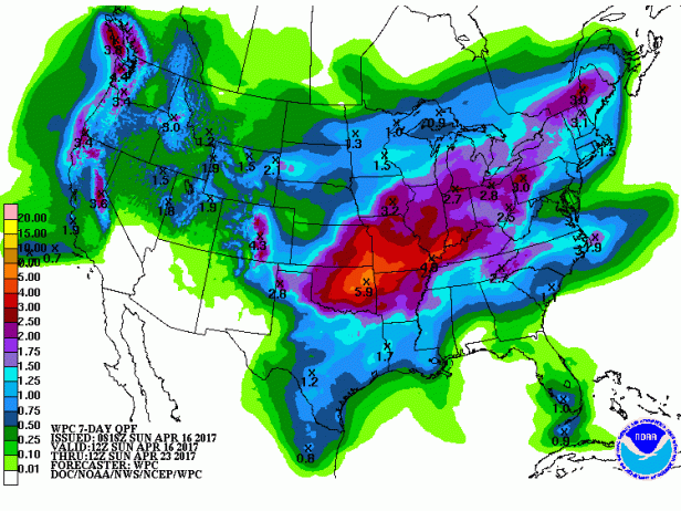
WPC total QPF for days 1-7: